
Rebuilding the Agriculture Office's Satellite Check | Subsidy Claim | GaianSpace CTF 2026
🌐 中文版:繁體中文
Fourth post in the series, and the finale of the “farm arc” (Babb’s AgriLink world). The first three posts got the LoRa demodulator in shape; this one adds a layer of GIS and classifier reconstruction on top of the demodulation.
In a way, it’s everything from the earlier posts applied together.
Rest of the series: Channel Hop、True Color Is a Lie、Isodata Seven、Two Voices、No Name on the Door、Hopscotch
What the challenge is about
At the county agriculture office, the area-payment claim for Babb’s north parcel was rejected: “parcel already declared as pasture, satellite check passed.” Someone filed a claim using Babb’s corn field, and the office’s satellite check actually sided with them.
A clerk lets something slip: this year the office’s classification stats left out one class, because “nobody around here declares that crop, and field surveys are expensive.” Separately, at 12:05 the shared SDR recorded a stranger transmitting this batch of claims on “yet another channel.”
Goal: find all the false claims in the stranger’s batch, and join their claim codes with hyphens in the order they were sent.
The files given are the SDR recording, the office’s check imagery (5-channel GeoTIFF), the class statistics, the training-field and parcel registry, and the rejection letter.
First, demodulate the claim batch from the SDR
The radio this time is 434.65 MHz, SF9, BW125k, preamble 8, explicit header, CR4/5.
Reusing the demodulator, 64 bursts decode to: one batch header + 30 claims + one short packet, and then the whole batch is sent again (so every record has two copies to cross-check).
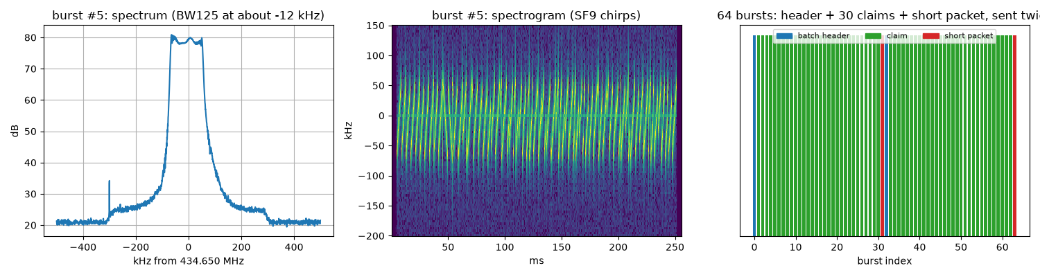
Each claim has the format <seq>;<parcel>;<declared crop>;<area>;<claim code>, e.g. 01;MZH-8140;legelo;44.67;CUVE (legelo = pasture).
The key: the class that got deleted
The office’s .sta file uses Gaussian maximum-likelihood classification with equal priors, but it has only four classes: pasture, stubble, cropland, settlement. You can see that corn (kukorica) was removed, and only its training field is still there.
A supervised classifier can only output classes it was trained on, so with no corn statistics, a corn field gets forced into the most similar class (pasture), and the check “passes.” That’s the core vulnerability of the whole challenge.
I first rasterized the training-field polygons onto the image grid and recomputed each class’s mean and covariance. They matched the .sta file byte for byte, confirming my coordinate and sampling conventions were correct.
Then I used training field T-01 to restore corn’s statistics, ran a 5-class classification, and compared record by record:
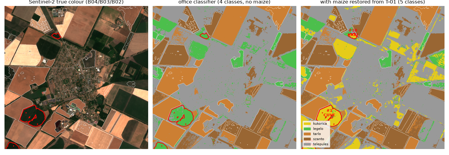
Under the office’s 4-class classification, all 30 records “pass.”
After restoring corn, only 3 records don’t match, and all three are “declared pasture, actually corn”:
| # | Parcel | Declared | After restoring corn | Code |
|---|---|---|---|---|
| 1 | MZH-8140 (Babb’s parcel) | pasture | corn 93% | CUVE |
| 10 | MZH-9183 | pasture | corn 84% | UKEJ |
| 28 | MZH-1402 | pasture | corn 80% | TRP6 |
Flag
1 | GAIANSPACE{CUVE-UKEJ-TRP6} |
Takeaways
- “One class is missing” is the whole key. A supervised classifier can only output classes it was trained on; with no corn statistics it crams corn into the most similar class, pasture, so “check passed” doesn’t mean the claim is honest. It’s a very realistic remote-sensing fraud scenario.
- Validate your own pipeline against known data first. Only after the training-field pixel counts and the
.stameans and covariances matched byte for byte did I go restore the missing class, which is what makes the conclusion hold up. - Make use of the re-send when decoding SDR batches. The two transmissions are identical, so you can cross-confirm every character instead of guessing.
- By this point the farm arc’s LoRa demodulator is quite mature. Next the series jumps to a different storyline, a night shift, a hijacked satellite, where the same demodulator meets trickier situations.
If you find my articles helpful, please support Kevin!
 Use boba to safe Kevin!